Images on Tsunami


1.                   On Dec. 26, 2004, at 7:59 AM local time, an undersea earthquake with a magnitude of 9.0 struck off the coast of the Indonesian island of Sumatra. The location of the earthquake and reach of the tsunami caused it to impact a large number of populated areas as well as waters frequented by fishing boats and other vessels, leading to a huge death toll. The areas marked in red, indicating where waves 12 to 14 feet high occurred, suffered the greatest devastation.                 Image


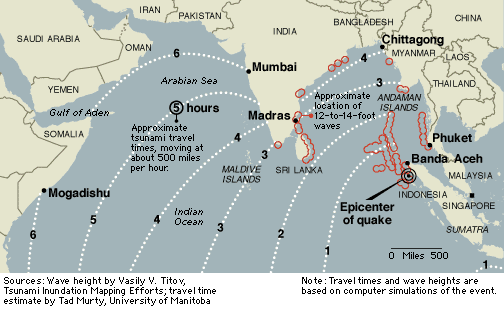
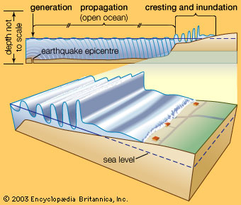
2.                 Following certain earthquakes, very long-wavelength water waves in oceans or seas sweep inshore. More properly called seismic sea waves or tsunamis (tsunami is a Japanese word for “harbour wave”), they are commonly referred to as tidal waves. After being generated by an undersea earthquake or landslide, a tsunami may propagate unnoticed over vast reaches of open ocean before cresting in shallow water and indundating a coastline.                                                      Image


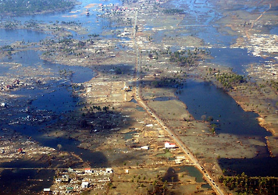
3.                 Aerial photo showing flattened houses in Banda Aceh, Indonesia, January 16, 2005, three weeks after a deadly tsunami devastated the island.                                                                                                  Image

4.                 Some more images showing the effect of tsunami.                                                                                                            Images